OklahomA Route 66
Route 66: Survey of Roadbed and Integral Structures
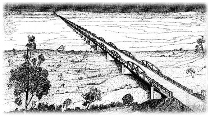
 Artists rendition of the William H. Murray (Bridgeport) Bridge from State Highway Commission Report.
The development of Route 66 as a major transportation corridor facilitated migration, culture, and tourism in twentieth-century America. Designated as U.S. Highway 66, the road stretched from Chicago, Illinois, to Santa Monica, California, and was one of several national highways established in 1926. Route 66, commonly known as “America’s Main Street,” ran approximately 400 miles through Oklahoma and served as the state’s first major east-west highway. It carried the traveling public across Oklahoma until the Interstate Highway System bypassed the corridor in the mid-twentieth century.
The Oklahoma Department of Transportation (ODOT) has long been committed to the preservation, interpretation, and management of Route 66. In 2002 ODOT was part of a team that prepared the report, “Oklahoma Route 66 Roadbed Documentation Project (1926-1970): A Survey of Roadbed and Integral structures,” available here: http://www.okhistory.org/shpo/thematic/rt66roadbed.pdf. ODOT has recently updated and created a digital map of this survey.
The Oklahoma Department of Transportation (ODOT) has long been committed to the preservation, interpretation, and management of Route 66. In 2002 ODOT was part of a team that prepared the report, “Oklahoma Route 66 Roadbed Documentation Project (1926-1970): A Survey of Roadbed and Integral structures,” available here: http://www.okhistory.org/shpo/thematic/rt66roadbed.pdf. ODOT has recently updated and created a digital map of this survey.
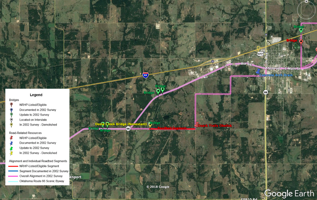
Google Earth layer
While Route 66 is well known for its tourism and roadside attractions, the essence of the highway is its roadbed, bridges, and other integral features, which are detailed in the digital map. Using Google Earth, this map provides the location and survey information on segments of roadbed and bridges along the various alignments of Route 66. Clicking on the icons within the map provides survey data associated with each resource, such as a date of construction, description, and photographs.
You can download the KMZ file here that will open as a layer in Google Earth:
You can download the KMZ file here that will open as a layer in Google Earth:
other resources
ODOT, the Oklahoma Historical Society, and the Oklahoma State Historic Preservation Office (SHPO) have completed additional projects on the history of Route 66. You can learn more at the following links:
ODOT
ODOT’s Memorial Highways & Bridges page provides historic background on Route 66 through Oklahoma, a detailed construction history of the road, and maps and pictures of the corridor: http://www.okladot.state.ok.us/memorial/route66/
ODOT
ODOT’s Memorial Highways & Bridges page provides historic background on Route 66 through Oklahoma, a detailed construction history of the road, and maps and pictures of the corridor: http://www.okladot.state.ok.us/memorial/route66/

Bridge Rail study - ODOT has completed a study of the Route 66 bridges in Oklahoma that still retain their original bridge rails in an effort to identify modern crash-tested rails that are historically compatible with the original railings. The recommendations for appropriate replacement railings are meant to identify replacement options that are acceptable in terms of safety requirements and visual compatibility. Click the image to the right to download the report.
Oklahoma Historical Society
The Oklahoma Historical Society has collected a list of Route 66 repositories with resources on the historic highway: http://www.okhistory.org/research/route66
Oklahoma SHPO
The SHPO has commissioned several historic surveys of Route 66 through Oklahoma:
The Oklahoma Historical Society has collected a list of Route 66 repositories with resources on the historic highway: http://www.okhistory.org/research/route66
Oklahoma SHPO
The SHPO has commissioned several historic surveys of Route 66 through Oklahoma:
- Route 66 in Oklahoma: A Historic Preservation Survey (1984)
- Oklahoma Route 66 Roadbed Documentation Project (1926-1970): A Survey of Roadbed and Integral Structures (2001-2002)
- Final Survey Report for the Oklahoma Route 66 Historic Resources Survey 1926-1970 (2002)
- Oklahoma Route 66 Roadbed Documentation Project (1926-1970): Part 2: Priorities and Management Strategies (2002-03)
- Route 66 in Oklahoma City Historic Context (2020)
- Thematic Survey of Route 66, Tulsa County, Oklahoma (2020)
